Rolling up to a new mountain biking destination and picking out the perfect trail can be more daunting than choosing the best fast food restaurant in you name it, middle America. The countless variables ranging from finding trail heads and optimal riding directions to arbitrary trail skill level ratings and crowd factors are all capable of overwhelming and inducing stress in the bike ride decision process. With over 400 miles of singletrack in the Sun Valley area, the near limitless options is sure to make your head spin. In an effort to keep your relationships in tact and maximize your time the saddle, we’ve created a mountain biking resource guide filled with maps, apps, guides and shops all ready to ease the trail selection pain.
The Best Map Local Resources
Every riding destination has a map that works best for their location. Sun Valley is no different. Here are best resources for the area:
BCRD – Blaine County Recreation District
- This is the local favorite for in-depth and up-to-date trail conditions, closures and reports. Their blog and weekly email is a great way to stay in the know.
- Viewing their map is best done via desktop computer direction on their site: http://summertrailink.bcrd.org
- See below for a slimmed down version
MTB Project
- The second most-mapped biking resource for the Sun Valley area is MTB Project
- They list out 32 trails covering 100+ miles
- Check out their map online, via their app or embedded below
Trail Forks
- Another widely used map service is Pink Bike’s – Trail Forks
- While there are less trails added here, it still is a great platform that covers several lesser-know rides
- Check out their map online or via their app
Singletracks
- This site is growing in popularity with trails added on a fairly regular basis
- One downside is that it only offers a web based version
- Check their map online here
Sun Valley Resort
- If you’re looking to ride over on Bald Mountain, Sun Valley Resort’s map offer extensive details on the trails available both via lift access and human powered
- Check out their map online
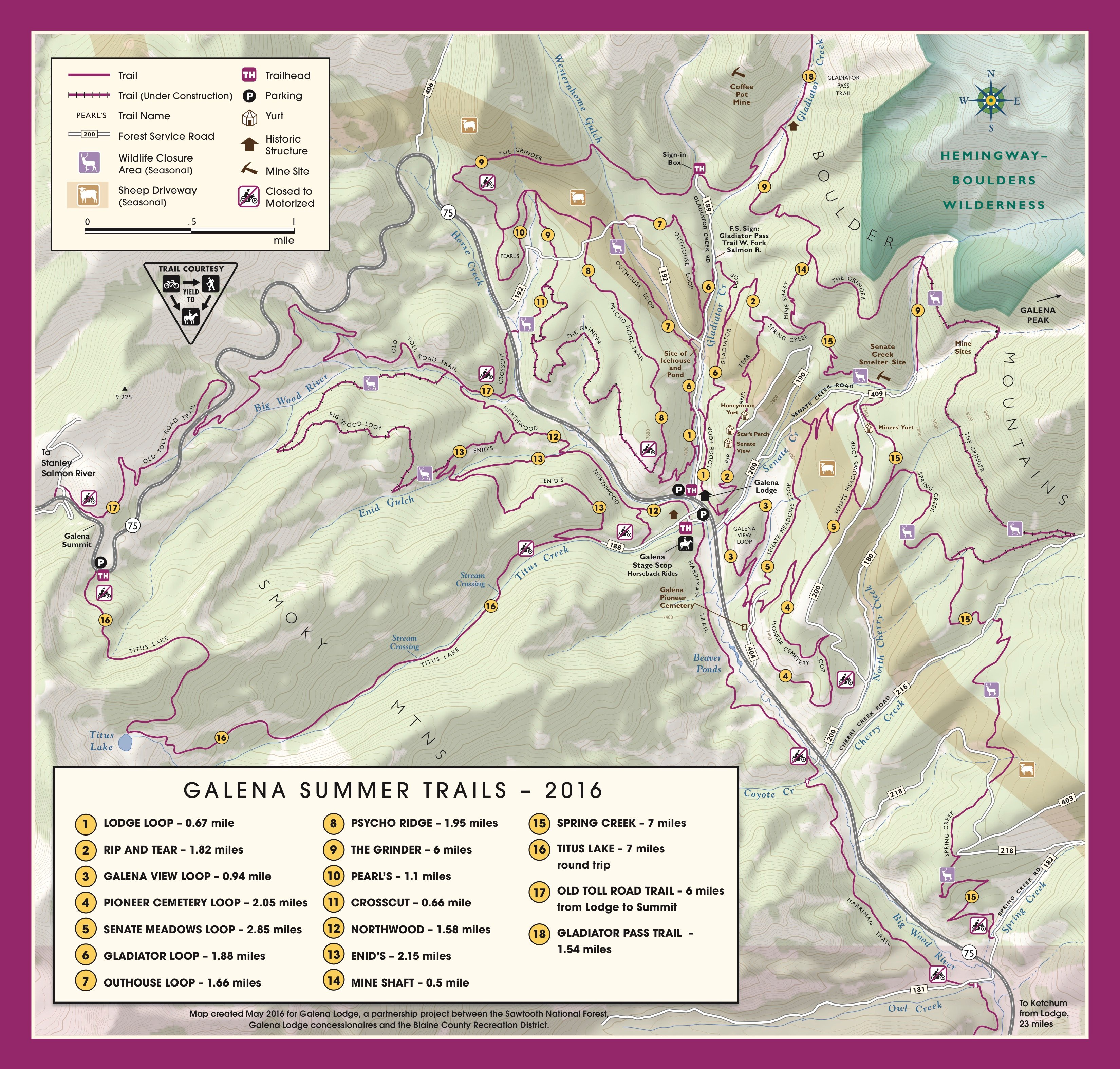
Galena Lodge Trails
- These are some of the newest trails in the area and as a result have not been added to many of the map resources.
- Check out their map online or below
Best Apps
Apps can be a life saver when trying to navigate out on the trails. Whether you’re on your smart phone or using a different GPS device, below are several applications that come in mighty handy.

- MTB Projects | best collection of trails for Sun Valley
![]()
- Trail Forks | second best collection of trails in the area
![]()
- Avenza | neat tool used for downloading a variety of maps or overlaying photos of trail maps with your smart phone’s GPS
![]()
- Strava | great way to get a perspective of what people in the Valley are riding
Guided Mountain Biking Companies
Sometimes a real person is the best biking companion you could ask for. There are a couple guide services in the Valley that will get you to the trailhead, ensure that you pack enough water for the ride, and give you a head-up when the tough climbs are impending.
Ask a Bike Shop
If you prefer an old fashioned map and a shop worker pointing out their favorite trails, stopping in at a local bike shop can be one of your best sources of intel. A 6-pack of beer for the mechanic goes a long ways when it comes to getting the top-secret intel. Here are a few recommended establishments to stop in to:
- Elephant’s Perch (Ketchum) | 208-726-3497 | 280 East Avenue Ketchum, ID 83340
- Sturtevant’s (Ketchum & Hailey) | 208-726-4501 | 340 N. Main Street, Ketchum, ID 83340 | Main St. Hailey
- Backwoods (Ketchum) | 208-726-8818 | 711 N Main Street, Ketchum ID 83340
- Sun Summit (Ketchum & Hailey) | 208-726-0707 | 791 Warm Springs Rd, Ketchum, ID 83340 | 418 S Main St, Hailey, ID 83333
- The Powerhouse (Hailey) | 208-78]8-9184 | 502 N Main St, Hailey, ID 83333
*Bonus Pro Tips
- Many of the trail heads around the valley including Croy Canyon, Greenhorn Gulch and Adam’s Gulch have maps at their trailhead. Instead of trying to engage your photographic memory, use your smartphone to snap a real picture of the map for reference. If can come in mighty handy when you’re wondering if it was the second left to take or a left-right-left variation to keep you on track.
- For a list of some of our favorite rides check our blog: Sun Valley, Idaho: Your Next Mountain Biking Bucket List Destination
Time to get out there and ride! If you have any other favorite resources, feel free to list them in the comments below!